The title
Islands of Music has been chosen because the metaphor
of islands is used to visualize music collections. The metaphor is based on islands, which represent groups of similar data items (pieces of music). These islands are surrounded by the sea, which corresponds to areas on the map where mainly outliers or data items, which do not belong to specific clusters, can be found. The islands can have arbitrary shapes, and there might be land passages between islands, which indicate that there are connections between the clusters. Within an island there might be sub-clusters. Mountains and hills represent these. A mountain peek corresponds to the center of a cluster and an island might have several mountains or hills.
More accurately a simple approximation of the probability density function is visualized
using a color scale which ranges from dark blue (deep sea) to light blue (shallow
water) to yellow (beach) to dark green (forest) to light green (hills) to gray
(rocks) and finally white (snow).
The sea level has been set to 1/3 of the total color range, thus map units with
a probability of less then 1/3 are under water. The sea level could be adjusted
by the user in real time, the involved calculations are neglectable. The visible
effects might aid understanding the islands and the corresponding clusters better.
The density function is estimated as follows. Each piece of music votes for the clusters (map units), which represents it best. The first closest model vector of
a corresponding unit gets
n points, the second
n-1, the third
n-2, and so forth. Thus units, which are close to several pieces of music, will get many points. While clusters, which are not close to any pieces, will hardly have any points. A map unit which is close to many pieces of music is very likely to be close to the center of a cluster, whereas a unit, which does not represent any pieces of music well, is likely to be an intermediate unit between clusters.
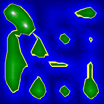
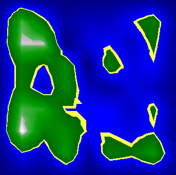
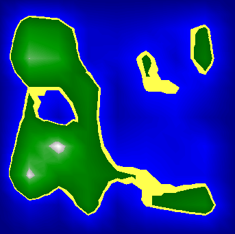
Figures 1 to 3 illustrate different parameter settings used to visualize the
demonstration. Notice that higher values for
n cause the islands to grow together while lower value result in many small and scattered islands. Since this parameter is applied at the very end of the whole process and can quickly be calculated the user can adjust this value in real time when exploring the map, and gain information not only from the structure of islands at a specific parameter setting, but also through analyzing differences between different settings.
|
|
Figure 1: n=1.
|
|
|
Figure 2: n=2.
|
|
|
Figure 3: n=3.
|
